Blog Posts Tagged ‘eastern-arizona’

Naming Contest Underway for Eaglet Hatched in Clarkdale this Week

2016 eaglet first pic

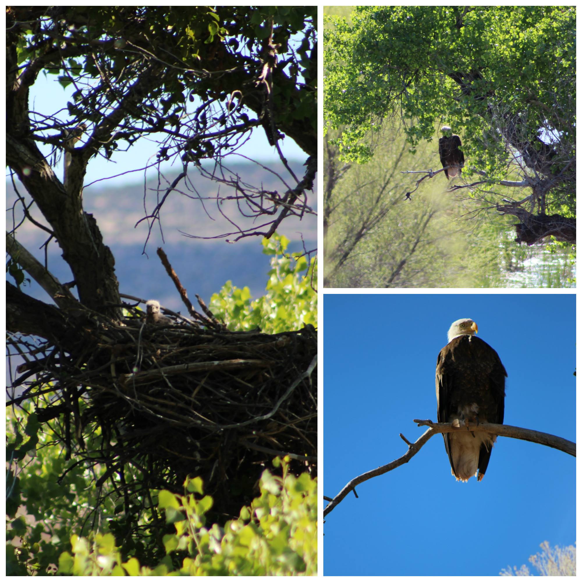
Word is quickly spreading that Clarkdale’s local celebrity Bald Eagle couple, Clark and Dale, successfully hatched a baby eaglet in their nest near TAPCO on the Verde River @ Clarkdale.  In February, 2014, Clark and Dale gained local recognition when their nest was discovered in a tree at the boat launch site that the Town of Clarkdale was developing as a public river access point.

To help insure protection of the nest site, and increase the chances that Clark and Dale would successfully fledge an eaglet, the Town of Clarkdale and land owner Freeport McMoran, Inc. took action immediately, and relocated the public river access point to its new location at the Lower TAPCO RAP (3400 Sycamore Canyon Road).

Unfortunately, Clark and Dale’s 2014 egg did not hatch, nor did the egg they laid in a nearby nest in the 2015 season.  This year, after a tip from Verde Canyon Railroad employees, Nest Watch volunteers documented that Clark and Dale had moved their nest to another new location (near the Verde Canyon Railroad tracks) and a single egg was incubated at the end of January, 2016.

Employees on the Verde Canyon Railroad have continued to observe Clark and Dale alternating shifts on the nest throughout the first quarter of the year, and were the first to report a sighting of the hatched eaglet in early April, 2016!

April will be a sensitive period for the young hatchling, as it will be vulnerable to the elements.  Strong spring winds in Arizona have been known to blow nests out of trees, killing the young hatchlings in the process.  At 4 to 8 weeks (during May), the vulnerability gradually decreases.  The biggest risks during this time occur if nestlings miss feedings or leave the nest prematurely due to disruption.  The period after the nestlings reach 8 weeks old (in early June) is another very sensitive time.   The eaglet is gaining flight capability, but may not be quite ready to test its wings.  If flushed from the nest prematurely due to disruption, the eaglet can die.

While uncharacteristic human activity in the area of the nest could pose disruption, the fact that Clark and Dale chose to nest near the train tracks indicates their tolerance for the daily trips associated with the Verde Canyon Railroad, and those trips should pose no unusual disruption for Clark, Dale and their young nestling.  Passengers on the train will get the enviable opportunity to catch a glimpse of the young nestling as it continues to mature before leaving the nest.  Because other activity in the area could pose a risk to the eagles, the Verde Canyon Railroad has established a Flickr photo page dedicated to watching the progress of this new eaglet!  Those who can’t ride the train to see the baby will have the opportunity to enjoy the progress here.

We’re hoping to see our young eaglet not only survive, but thrive, and take to the air sometime in June.  As we continue to follow its progress, we’d like the public to weigh in to help name the young eaglet.  On-line voting for a name will begin April 11th on the Town of Clarkdale website.

Alison Zelms

Deputy City Manager
City of Prescott

Alison Zelms - Prescott

Many city or town employees have positions that require them to “wear many hats” in their day-to-day responsibilities. For some, the idea of taking on multiple projects and job titles could seem overwhelming. But Prescott Deputy City Manager Alison Zelms knows a thing or two about variety and tackles multiple projects like a pro.

Having grown up on Air Force bases around the world as a child, Zelms had the opportunity to move to different places, see the world and gain perspective. She spent time in West Germany and saw first-hand the vast differences in lifestyle from each side of the Berlin Wall. It was her experience witnessing West and East Berlin that inspired her interest in the importance and daily impact of public policy.

Taking these early-learned passions, Zelms went on to receive her bachelor’s degree and Master in Public Administration. During graduate school at the University of Arkansas, she began her work in local government, starting at the state’s Bureau of Labor Market Information. From there she became an assistant to the city manager in University Park, Texas, followed by a position in Evanston, Illinois as management analyst in charge of a $175 million operating budget.

Alison was brought to Arizona through an assistant city manager position with the City of Sedona. It was there that she honed her skills in multi-tasking as she oversaw the finance, economic planning, information technology, arts and culture, communications and public works departments. She also started the City of Sedona’s first intergovernmental relations program, serving as their legislative liaison in addition to her regular duties.

In December, Alison celebrated four years of service with the City of Prescott. Drawing on her experience in legislative work from Scottsdale, one of her “many hats” in Prescott also includes serving as the city’s intergovernmental affairs liaison. Within this role, she monitors legislation, develops the city’s annual legislative policy with the city council and communicates the city’s positions during the legislative session. Multitasking is essential for Zelms and any “part-time intergov,” whose full-time positions only offer them minimal time to work on legislative issues, as she is also responsible for oversight of seven operational areas and is engaged in budget development, personnel management, policy implementation and day-to-day operations.

Zelms thrives in the variety of her multi-faceted position. Though it can be a challenge to cover so much ground, she appreciates the combination of broad supervisory duties and leadership on complex policy issues, in addition to continuous education on new issues and making new connections between people and topics.

“This position is never boring,” said Zelms. “There are always opportunities for even small gains to be made in gaining an audience for an issue or creating solutions.”

Floyd Gilmore

Show Low Cemetery Grave Digger
City of Show Low

Gilmore_001


It is difficult to imagine that anyone can be passionate about digging graves, but Floyd Gilmore has dug more than 1,000 graves in the city-owned cemetery since 1976 as an independent backhoe operator. He finds the work fascinating and, sometimes, even exciting, because he “gets to do things no one else has ever done.”

“According to Arizona law, a body doesn’t have to be embalmed if it is buried within 24 hours of death,” says Gilmore. He recalls fielding a frantic call from a local mortician asking that a grave be dug within three hours—or miss the 24-hour window. The decedent, a white male, was buried wrapped in a handmade Indian blanket, a gift for his many years of working alongside Navajos and Apaches on their reservations.

Gilmore buried one of his grown sons in the same manner, whose last wish was to not be embalmed. He was assisted by his other three sons and grandchildren. Gilmore says, “It’s like a family tradition. My kids have always helped me dig graves.”

Floyd Gilmore - Show Low 2

With almost 40 years of experience, Gilmore has disinterred graves across Apache and Navajo counties. Often, the graves are on private property and the new owners want them transplanted. One job was to disinter five graves—four children ages four to 11 and one uncle—who died from an influenza epidemic in the early 1900s. Similar to an archaeological dig, Gilmore and his grandchildren used whisk brooms to clear away the dirt from the remains buried in homemade pine caskets disintegrated by time and moisture. “Moisture is what causes decay,” says Gilmore.

As proof, he recalls disinterring the graves of a family buried in dry sand on a private ranch in Apache County.  The earliest, the father, was buried in 1876, the mother in 1890, and the children in early 1900. The pine boxes holding the decedents were intact and the mother was mummified, her clothes and blond hair otherwise uninterrupted by time.

Next time you visit a cemetery, check the headstones and see what intriguing story you might uncover.

Escudilla Mountain

(Courtesy photo)

(Courtesy photo)

Escudilla Mountain is located in the White Mountains of Eastern Arizona near the town of Eagar. It is considered the third highest mountain in Arizona, and like the others, is volcanic in origin. Though there are eleven higher named summits in the state, most are considered subpeaks of either Humphrey’s Peak or Mount Baldy. The name Escudilla is Spanish for “a small bowl,” and the mountain may have been named by early Hispanic settlers in the region, or possibly by a member of Coronado’s 1540 Expedition through the Southwest. In 1984 the Escudilla Wilderness Area was created, encompassing 5,200 acres of Escudilla Mountain and the surrounding area of the Apache National Forest. Two primary trails are utilized for this moderate dayhike. The scenic Escudilla National Recreation Trail #308 is used by most hikers while the steeper Government Trail #119 receives less traffic since it is slightly longer with fewer views of the surrounding lowlands. They may be combined to form a loop. The fire lookout tower on Escudilla Mountain is the highest in Arizona although it is not on the true summit. A climb to the top of it offers spectacular views into New Mexico and the surrounding area. Mount Baldy can be seen to the west. The tower is occupied daily and permission should be acquired from the lookout before ascending the steps. Permission will not be granted if it is raining. For more information and park updates, visit: http://www.fs.usda.gov/recarea/asnf/recreation/recarea/?recid=45293&actid=50.

Apache-Sitgreaves National Forest

(Courtesy photo)

(Courtesy photo)

The Apache and the Sitgreaves National Forests were administratively combined in 1974 and are now managed as one unit from the Forest Supervisor’s Office in the town of Springerville. The 2 million-acre forest encompasses magnificent mountain country in east-central Arizona along the Mogollon Rim and the White Mountains.

What makes this forest so special? Its the water – and plenty of it – draining the high mountains and forming numerous lakes and streams, making it a fisherman’s paradise, or for anyone else who enjoys a lakeside view coupled with a beautiful, mountainous backdrop in the arid Southwest.

The Apache-Sitgreaves has 34 lakes and reservoirs and more than 680 miles of rivers and streams – more than can be found in any other Southwestern National Forest. The White Mountains contain the headwaters of several Arizona rivers including the Black, the Little Colorado, and the San Francisco.

The Sitgreaves was named for Captain Lorenzo Sitgreaves, a government topographical engineer who conducted the first scientific expedition across Arizona in the early 1850’s. On the Sitgreaves, the major attractions for visitors from the hot valleys of Phoenix or Tucson are the Mogollon Rim and the string of man-made lakes. From the Rim’s 7600-foot elevation, vista points provide inspiring views of the low country to the south and west.

In the last century, the U.S. Army established a series of forts in New Mexico and Arizona. To supply these forts and settlements, a military road was built linking Sante Fe, New Mexico and Camp Verde near Prescott. Part of this road, called the General Crook Trail, runs almost the length of the Sitgreaves and in many places follows the brink of the Rim.

The Apache National Forest is named after the tribes that settled in this area. It ranges in elevation from 3500 feet near Clifton to nearly 11,500 feet on Mount Baldy. The congressionally proclaimed Mount Baldy, Escudilla, and Bear Wallow wildernesses and the Blue Range Primitive Area make the Apache one of America’s premier backcountry Forests. The Apache is also noted for its trout streams and high-elevation lakes and meadows.

With the abundance of natural beauty one can take in on a hike or setting up camp, along with the rich history of this vast area, what’s not to love?

For more information and park updates, visit: http://www.fs.usda.gov/asnf.

Stinson Pioneer Museum

(Courtesy photo)

(Courtesy photo)


The Stinson Pioneer Museum, located in the town of Snowflake, houses artifacts and pictures from the early days of Snowflake, from prehistoric Indians to 19th century pioneers. Included on display is the loom used by Lucy Hannah Flake to weave cloth and rag rugs. Two rooms have been restored to depict the living conditions of the early pioneer families.

Additionally, the town has more than 100 historical buildings, most restored to their original condition, which can be seen in this walking tour. Spinning, weaving, blacksmithing, and quilting demonstrations are also available, as well as a horse drawn wagon for groups by appointment.

Come visit historic Snowflake and admire the dedication and hard work of the pioneers who built the foundation of what the beautiful and peaceful town is today.

Lyman Lake State Park

(Courtesy photo)

(Courtesy photo)


Created as an irrigation reservoir by damming the Little Colorado River, Lyman Lake State Park is located off the State Route 180 between towns of St. Johns and Springerville. The lake is a 1,200-acre park that encompasses the shoreline of a 1,500-acre reservoir at an elevation of 6,000 feet. It is fed by snowmelt from the slopes of Mount Baldy and Escudilla Mountain, the second and third highest mountains in Arizona. Water is channeled into this river valley from a 790-square-mile watershed extending into New Mexico.

Because of its size, Lyman Lake is one of the few bodies of water in Northeastern Arizona with no size restrictions on boats, however certain areas are buoyed off in order to create a peaceful (and successful) fishing area. The fishery consists of walleye, channel catfish and largemouth bass. The large remainder of the lake is open for all other types of water sports.

Lyman Lake really comes into its own during the spring, summer, and fall. Summer days, with temperature highs in the 80’s to low 90’s, are perfect for fishing, swimming, leisure boating, water-skiing, hiking or just plain relaxing.

For more information, visit: http://azstateparks.com/Parks/LYLA/.

Arizona’s Salsa Trail

(Courtesy photo)

(Courtesy photo)


Arizona’s Salsa Trail® is all about terrific Mexican food and down-home friendliness. Sprinkled through the small Southern Arizona communities of Safford, Pima, Thatcher, Solomon, Clifton, Duncan, Willcox, and York are a dozen Mexican restaurants, a family owned tortilla factory and a lady who grows chilies who have all joined together to make up the Salsa Trail®.

The scenic Old West Highway connects the communities and businesses which are within a 40 mile radius of Safford – about and hour and a half east and slightly north of Tucson.

In addition to good food and friendly folks, tourists are beginning to discover the natural beauty and tucked away attractions that dot the map along the Salsa Trail®. There are over 4 million acres of National Forest and protected Wilderness lands, pristine high desert beauty, the lush Gila Valley, and towering pines on Mount Graham. Graham County is filled with so many things to do throughout it’s little communities, and has some of the most beautiful scenic terrain in the entire Southwest. It’s no wonder first time visitors frequently come back for more.

For more information, visit: http://www.salsatrail.com/.

Eastern Arizona Museum and Historical Society

A section of railroad being built in Eastern Arizona, circa 1900. (Courtesy photo)

A section of railroad being built in Eastern Arizona, circa 1900. (Courtesy photo)


Enjoy reading up on some Eastern Arizona history by visiting the Eastern Arizona Museum and Historical Society located in the town of Pima. The building the museum is located in is, in itself a historical piece, as it used to be the Bank of Pima, the oldest structure in Pima. The building was constructed in 1882 of tufa stone from the limestone quarry at Bear Springs Flat and was originally used as a community conference area. Of the trio of historical buildings used for the museum is the Old Rexall Drug Store, built around 1900 and moved to the old Royal Confectionery building in 1928. When you step inside the museum, it’s as though everything inside the building had been frozen in time from the early 1900s, with original fixtures, tools, and various items that had long since been left behind by their owners.

Museum collections include:

American Indian Artifacts

Arizona History books

Barbed wire collections

Guns and knives

Hand tools

Handwork

Individual and family histories

Photographs

Quilts

School Annuals and Artifacts

Vintage clothing, shoes, jewelry and grooming items

Wood carvings – an extensive collection by local Don McFate

For museum operating hours and more information about the museum, please visit: http://easternarizonamuseum.com/.

Kearny Lake

(Courtesy photo)

(Courtesy photo)


Kearny Lake, while it has been fisherman’s best-kept secret as a prime place to catch bass and catfish, has also attracted those who want a peaceful, lakeside picnic, or enjoy some outdoors with some camping, is located off of State Route 177 just outside of the town of Kearny.

After a major portion of the existing park was swept away from a flood in 1983, town  and park officials decided they would create a lake, as well as set up places for picnics and camping (with 12 campsites available). Today, the area is managed by the Kearny Parks Department, and the lake is stocked from November to March with catchable-sized rainbow trout. Other species available include largemouth bass, catfish and, of course, sunfish. Boats are allowed on the lake, although motors are limited to electric trolling motors.

It may be a small and humble recreational area, but with the seclusion its a fisherman’s or outdoorsman’s dream.