Blog Archive for the ‘AZ Cities @ Work’ Category

Vote Your Main Street – City of Casa Grande

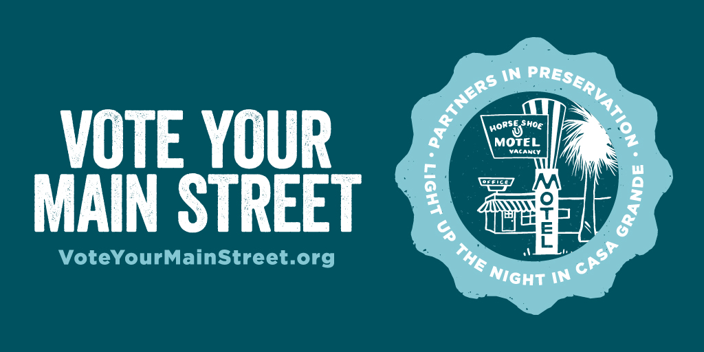
The City of Casa Grande is proud to partner with Casa Grande Main Street to participate in the “Partners in Preservation: Main Streets” national campaign to create a vintage Neon Sign Park in historic Casa Grande.  As the only Arizona community competing, Mayor Craig McFarland is encouraging Casa Grande residents and the surrounding communities to vote for the project at VoteYourMainStreet.org.

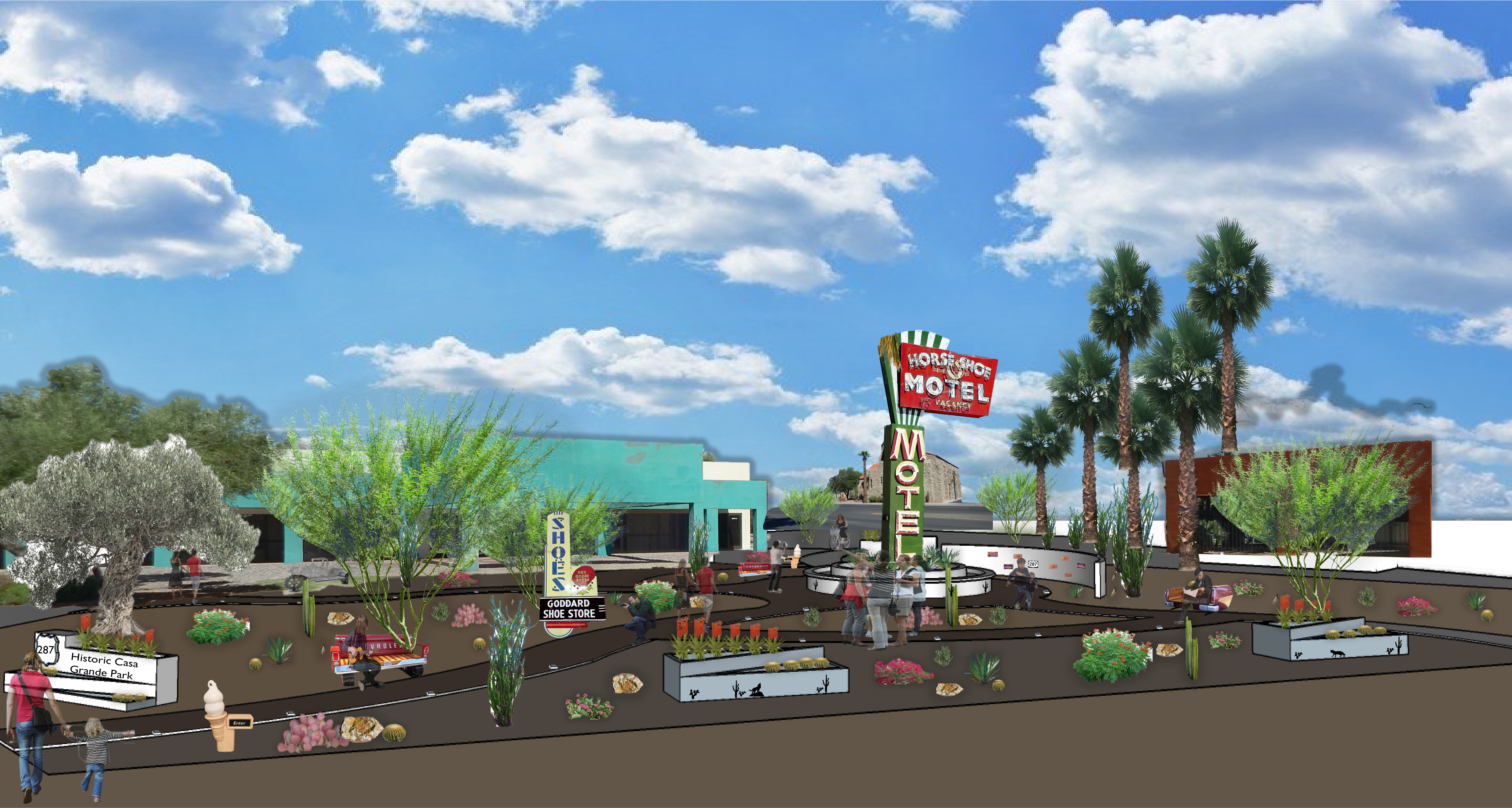
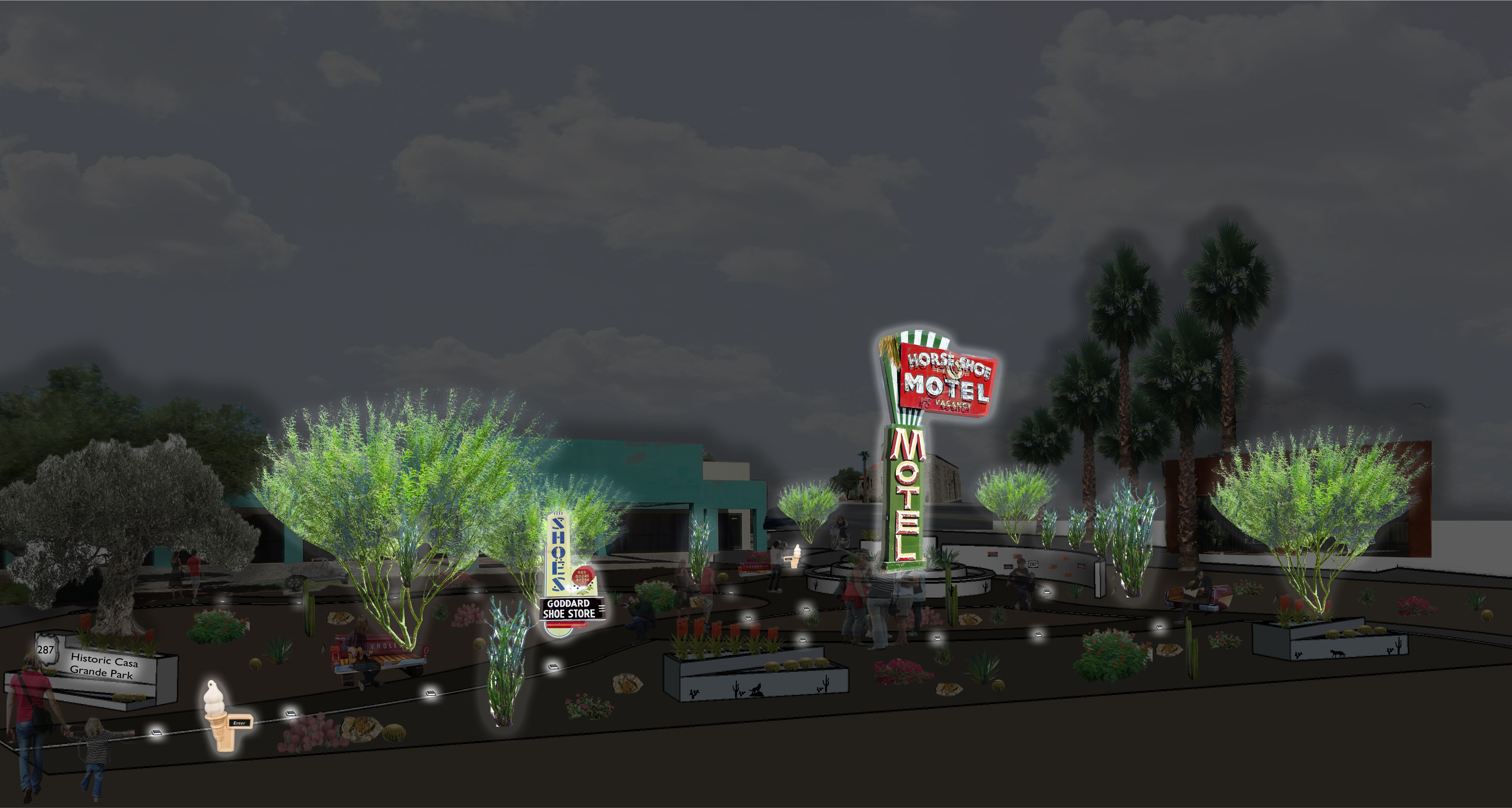
Located at the Arizona Plaza at 408 N. Sacaton Street (between Florence Boulevard and 2nd Street), the proposed Neon Sign Park will contain salvaged historic neon signs from throughout the community, and will serve as a vibrant downtown destination for visitors.

“This is the perfect opportunity for Casa Grande to showcase its community pride, all by simply voting daily,” said Casa Grande Mayor Craig McFarland. “We may be the underdog compared to other larger competing cities, but I have complete confidence in the dedication and power of our residents to vote early, vote often, and help us create this unique space.”

The public may vote up to five times daily through October 31, and winners will be announced on November 2. The sites with the most votes will get grants of up to $150,000 each, with as many projects funded as possible from a pool of $1.5 million.

In an effort to highlight local preservation efforts and promote the campaign, Casa Grande Main Street will host a Media Open House and Community Mural Event on Saturday, October 7 at the proposed park site. The event will include a press conference to start at 11:00 am, followed by a community mural event that celebrates historic sites until 2:00 pm.

Partners in Preservation is a community-based partnership, created by the National Trust for Historic Preservation and American Express, to raise awareness of the importance of preserving historic places and their role in sustaining local communities. Partners in Preservation: Main Streets will award $2 million in grant funding from American Express to Main Street districts in need of preservation support across America.

For more information about the “Partners in Preservation: Main Streets” projects, or to place your vote, please click here. For more information about Casa Grande Main Street or the proposed Neon Sign Park, please contact Casa Grande Main Street Director, Rina Rien at (520) 836-8744.

Mortimer Family Farms


Sometimes you need to break away from the city to fully enjoy the seasons. Dewey-Humboldt’s Mortimer Family Farms allows visitors to do just this.

During the summer, Mortimer Family Farms holds the Sweet Corn Festival. The Corn Festival occurs every weekend in August.

About the festival via the Mortimer Family Farms website:

This festival will feature everything “CORN!” Come join us for the “a-MAIZE-ing” attractions, games, farm activities, barn dance, and much more! Admission is only $10.00 per person which includes entertainment for the entire family! Younger guests will enjoy the Pig Races, Farm Animal Petting Zoo, Buckaroo Pony Corner, Farm Slide, Corn Bath, Straw Maze, Barrel Train, Bounce Playhouse Farmland, and Barrel Train! Teen guests won’t want to miss the Bubble Run, Pig Races, Laser Tag, Roping Dummies, Obstacle Course, Water Rides, and Lawn Mower Races!

The whole family will relish Fresh Picked Sweet Corn, Vegetables, Antique Tractor Show, Hay Rides, Music, Barn Dance, Live Entertainment, Craft Vendors, and “a-MAIZE-ing” farm food set in the middle of our growing fields! Are you competitive? Test your skills with a Corn Eating competition, Corn Shucking competition, and Corn Toss with prizes being awarded!

The Mile High Tractor Club will be displaying antique tractors for all to enjoy! Watch as they compete for “Top Pull” every Saturday, seeing which Operator & Antique Tractor can pull the weighted sled the farthest.

Meet Farmer Buzz on a hayride tour of the farm with lots of stories and history about our area – he will even take you to the fields to pick your own Sweet Corn right off the stalk. Learn about agriculture, the history of Dewey-Humboldt, and watch a real Blacksmith create works of art in iron!

Join us for our Farm Dance, both Saturdays, in our 4 – 7 Barn. The dance is for all ages to enjoy and it is a MUST! Be ready for this Boot Scootin’ good time from 7:00 to 10:00 pm along with all festival attractions.

Farm Market Store and “My Grandma’s Kitchen” is open daily from 8-6 where you will find farm raised: Sweet Corn, Tomatoes, Peppers, Squash, Zucchini, Cucumbers, Herbs, Black Angus Beef, Chicken, Home baked Cookies, Pies, Cakes, Fudge, Sandwiches and more! Their baked goods utilize farm fresh ingredients, making everything from scratch – Just like Grandma always did! The recipes are family favorites and they are delicious.

The vegetables have arrived! The store and festival will be loaded with Sweet Corn, Tomatoes, Squash, Peppers and other Summer Vegetables grown on the Farm!


Mortimer Family Farms hosts events throughout the year. Keep connected with Mortimer Family Farms on Facebook and Twitter to learn about other upcoming events!

Parker Dam

parker dam_ CO river_8.11.14

Photo courtesy of usbr.gov

The Parker Dam may not seem like much to the average onlooker, but the dam is greater than it seems. While most of the dam is not visible to those on the ground, it is said to be the deepest in the world. The majority of it just happens to sit below water.

The dam is located on the border between Arizona and California. The dam was build between 1938 and 1938 by the Bureau of Reclamation. It was created to bring both power and drinking water to Southern California. It is 320 feet (98 meters) high and 856 feet (261 meters) long. It separates Lake Havasu from the Colorado River.

Visitors can camp near the dam at one of the two public campground that are located along the Colorado River.

Read more about the dam’s history here at the nps.gov webiste.

London Bridge

Arizona has its own piece of London. Located in Lake Havasu City is the London Bridge.

The bridge formerly spanned the River Thames in London, England until it was dismantledi n 1967.

The Arizona bridge, as it stands now, is a reinforced concrete structure clad in the original masonry of the 1830s bridge, which was brought by Robert P. McCulloch from London. McCulloch had exterior granite blocks from the original bridge numbered and transported to America to construct the present bridge in Lake Havasu City. The bridge was completed in 1971 and links an island in the Colorado River with the main part of Lake Havasu City.

The bridge’s relocation was the basis of a 1985 made-for-television movie Bridge Across Time, also known as Arizona Ripper or Terror at London Bridge. In the film, a series of murders in Lake Havasu is attributed to the spirit of Jack the Ripper, whose soul is transported to the united States in one of the stones of the bridge.

So, the next time you’re yearning for a trip to London (but can’t exactly afford the great vacation), maybe plan a trip to Lake Havasu City instead. Then you can pretend you’ve escaped to the prestigious city while remaining right in  the desert oasis that is Arizona.

Flagstaff Aquaplex

Courtesy of flagstaffaquaplex.org

Courtesy of flagstaffaquaplex.org

The Aquaplex is a multi-generational, multi-scheduled community recreation center. The Aquaplex offers affordable community fitness and fun for everyone! Swimming Lessons, Kids’ Climbing Wall, Open Gym, Recreational Swimming and more. They are open seven days a week for your fun and fitness.

The Aquaplex offers a full spectrum of programs, drop-in activities and events to help you reach and keep yourself and your family healthy.

See this and more at the main Aquaplex website.

Escudilla Mountain

(Courtesy photo)

(Courtesy photo)

Escudilla Mountain is located in the White Mountains of Eastern Arizona near the town of Eagar. It is considered the third highest mountain in Arizona, and like the others, is volcanic in origin. Though there are eleven higher named summits in the state, most are considered subpeaks of either Humphrey’s Peak or Mount Baldy. The name Escudilla is Spanish for “a small bowl,” and the mountain may have been named by early Hispanic settlers in the region, or possibly by a member of Coronado’s 1540 Expedition through the Southwest. In 1984 the Escudilla Wilderness Area was created, encompassing 5,200 acres of Escudilla Mountain and the surrounding area of the Apache National Forest. Two primary trails are utilized for this moderate dayhike. The scenic Escudilla National Recreation Trail #308 is used by most hikers while the steeper Government Trail #119 receives less traffic since it is slightly longer with fewer views of the surrounding lowlands. They may be combined to form a loop. The fire lookout tower on Escudilla Mountain is the highest in Arizona although it is not on the true summit. A climb to the top of it offers spectacular views into New Mexico and the surrounding area. Mount Baldy can be seen to the west. The tower is occupied daily and permission should be acquired from the lookout before ascending the steps. Permission will not be granted if it is raining. For more information and park updates, visit: http://www.fs.usda.gov/recarea/asnf/recreation/recarea/?recid=45293&actid=50.

Apache-Sitgreaves National Forest

(Courtesy photo)

(Courtesy photo)

The Apache and the Sitgreaves National Forests were administratively combined in 1974 and are now managed as one unit from the Forest Supervisor’s Office in the town of Springerville. The 2 million-acre forest encompasses magnificent mountain country in east-central Arizona along the Mogollon Rim and the White Mountains.

What makes this forest so special? Its the water – and plenty of it – draining the high mountains and forming numerous lakes and streams, making it a fisherman’s paradise, or for anyone else who enjoys a lakeside view coupled with a beautiful, mountainous backdrop in the arid Southwest.

The Apache-Sitgreaves has 34 lakes and reservoirs and more than 680 miles of rivers and streams – more than can be found in any other Southwestern National Forest. The White Mountains contain the headwaters of several Arizona rivers including the Black, the Little Colorado, and the San Francisco.

The Sitgreaves was named for Captain Lorenzo Sitgreaves, a government topographical engineer who conducted the first scientific expedition across Arizona in the early 1850’s. On the Sitgreaves, the major attractions for visitors from the hot valleys of Phoenix or Tucson are the Mogollon Rim and the string of man-made lakes. From the Rim’s 7600-foot elevation, vista points provide inspiring views of the low country to the south and west.

In the last century, the U.S. Army established a series of forts in New Mexico and Arizona. To supply these forts and settlements, a military road was built linking Sante Fe, New Mexico and Camp Verde near Prescott. Part of this road, called the General Crook Trail, runs almost the length of the Sitgreaves and in many places follows the brink of the Rim.

The Apache National Forest is named after the tribes that settled in this area. It ranges in elevation from 3500 feet near Clifton to nearly 11,500 feet on Mount Baldy. The congressionally proclaimed Mount Baldy, Escudilla, and Bear Wallow wildernesses and the Blue Range Primitive Area make the Apache one of America’s premier backcountry Forests. The Apache is also noted for its trout streams and high-elevation lakes and meadows.

With the abundance of natural beauty one can take in on a hike or setting up camp, along with the rich history of this vast area, what’s not to love?

For more information and park updates, visit: http://www.fs.usda.gov/asnf.

Stinson Pioneer Museum

(Courtesy photo)

(Courtesy photo)


The Stinson Pioneer Museum, located in the town of Snowflake, houses artifacts and pictures from the early days of Snowflake, from prehistoric Indians to 19th century pioneers. Included on display is the loom used by Lucy Hannah Flake to weave cloth and rag rugs. Two rooms have been restored to depict the living conditions of the early pioneer families.

Additionally, the town has more than 100 historical buildings, most restored to their original condition, which can be seen in this walking tour. Spinning, weaving, blacksmithing, and quilting demonstrations are also available, as well as a horse drawn wagon for groups by appointment.

Come visit historic Snowflake and admire the dedication and hard work of the pioneers who built the foundation of what the beautiful and peaceful town is today.

Lyman Lake State Park

(Courtesy photo)

(Courtesy photo)


Created as an irrigation reservoir by damming the Little Colorado River, Lyman Lake State Park is located off the State Route 180 between towns of St. Johns and Springerville. The lake is a 1,200-acre park that encompasses the shoreline of a 1,500-acre reservoir at an elevation of 6,000 feet. It is fed by snowmelt from the slopes of Mount Baldy and Escudilla Mountain, the second and third highest mountains in Arizona. Water is channeled into this river valley from a 790-square-mile watershed extending into New Mexico.

Because of its size, Lyman Lake is one of the few bodies of water in Northeastern Arizona with no size restrictions on boats, however certain areas are buoyed off in order to create a peaceful (and successful) fishing area. The fishery consists of walleye, channel catfish and largemouth bass. The large remainder of the lake is open for all other types of water sports.

Lyman Lake really comes into its own during the spring, summer, and fall. Summer days, with temperature highs in the 80’s to low 90’s, are perfect for fishing, swimming, leisure boating, water-skiing, hiking or just plain relaxing.

For more information, visit: http://azstateparks.com/Parks/LYLA/.

Arizona’s Salsa Trail

(Courtesy photo)

(Courtesy photo)


Arizona’s Salsa Trail® is all about terrific Mexican food and down-home friendliness. Sprinkled through the small Southern Arizona communities of Safford, Pima, Thatcher, Solomon, Clifton, Duncan, Willcox, and York are a dozen Mexican restaurants, a family owned tortilla factory and a lady who grows chilies who have all joined together to make up the Salsa Trail®.

The scenic Old West Highway connects the communities and businesses which are within a 40 mile radius of Safford – about and hour and a half east and slightly north of Tucson.

In addition to good food and friendly folks, tourists are beginning to discover the natural beauty and tucked away attractions that dot the map along the Salsa Trail®. There are over 4 million acres of National Forest and protected Wilderness lands, pristine high desert beauty, the lush Gila Valley, and towering pines on Mount Graham. Graham County is filled with so many things to do throughout it’s little communities, and has some of the most beautiful scenic terrain in the entire Southwest. It’s no wonder first time visitors frequently come back for more.

For more information, visit: http://www.salsatrail.com/.