Blog Posts Tagged ‘history’

Apache-Sitgreaves National Forest

(Courtesy photo)

(Courtesy photo)

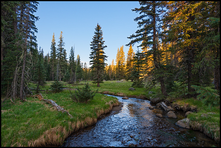
The Apache and the Sitgreaves National Forests were administratively combined in 1974 and are now managed as one unit from the Forest Supervisor’s Office in the town of Springerville. The 2 million-acre forest encompasses magnificent mountain country in east-central Arizona along the Mogollon Rim and the White Mountains.

What makes this forest so special? Its the water – and plenty of it – draining the high mountains and forming numerous lakes and streams, making it a fisherman’s paradise, or for anyone else who enjoys a lakeside view coupled with a beautiful, mountainous backdrop in the arid Southwest.

The Apache-Sitgreaves has 34 lakes and reservoirs and more than 680 miles of rivers and streams – more than can be found in any other Southwestern National Forest. The White Mountains contain the headwaters of several Arizona rivers including the Black, the Little Colorado, and the San Francisco.

The Sitgreaves was named for Captain Lorenzo Sitgreaves, a government topographical engineer who conducted the first scientific expedition across Arizona in the early 1850’s. On the Sitgreaves, the major attractions for visitors from the hot valleys of Phoenix or Tucson are the Mogollon Rim and the string of man-made lakes. From the Rim’s 7600-foot elevation, vista points provide inspiring views of the low country to the south and west.

In the last century, the U.S. Army established a series of forts in New Mexico and Arizona. To supply these forts and settlements, a military road was built linking Sante Fe, New Mexico and Camp Verde near Prescott. Part of this road, called the General Crook Trail, runs almost the length of the Sitgreaves and in many places follows the brink of the Rim.

The Apache National Forest is named after the tribes that settled in this area. It ranges in elevation from 3500 feet near Clifton to nearly 11,500 feet on Mount Baldy. The congressionally proclaimed Mount Baldy, Escudilla, and Bear Wallow wildernesses and the Blue Range Primitive Area make the Apache one of America’s premier backcountry Forests. The Apache is also noted for its trout streams and high-elevation lakes and meadows.

With the abundance of natural beauty one can take in on a hike or setting up camp, along with the rich history of this vast area, what’s not to love?

For more information and park updates, visit: http://www.fs.usda.gov/asnf.

Morenci Mine Overlook

(Courtesy photo)

(Courtesy photo)


Morenci and neighboring Clifton share a common history of copper mining, and are today commonly referred to as the Clifton-Morenci district. Copper was discovered in Morenci in 1872 and mining began the following year. Both towns have had a cyclical history of booms and busts, and today downtown Clifton is nearly abandoned, with most economic activity centered in Morenci. The area’s largest employer is Freeport-McMoRan.

Geronimo is said to have been born near the current site of Clifton, and well-known southwest impressionist artist Ettore DeGrazia was born in Morenci.

World’s Smallest Museum

Photo Courtesy of World's Smallest Museum

Photo Courtesy of World’s Smallest Museum

We tend to focus on the things that make the loudest noises in our lives, but it’s important to take some time to appreciate the littler things, too. The World’s Smallest Museum hones in on this concept. The museum, standing at only 134 square feet displays common yet unique artifacts. A visit to the World’s Smallest Museum is a step back in time and a stroll down memory lane.

Included in the exhibit is a 1984 Compaq home computer, a Beatles concert poster, a 1960 letter from president-elect John F. Kennedy (to Jake Reaney), and the World’s Largest Apache Tear, which is a kind of rock.

Just outside of the museum is Waterfall Avenue and Memory Lane. These attractions are decorated with the artifacts of ordinary working equipment that have been recycled into fountains and waterfalls. It includes monuments to the unsung heroes and hardworking people of the world.

Superstition Mountain Museum

Photo Courtesy of Superstition Mountain Museum

Photo Courtesy of Superstition Mountain Museum

Nestled in the east valley of the city of Apache Junction the Superstition Mountain Historical Society was formed on December 27, 1979.  As a non-profit corporation under Section 501 (c) 3, funding goes to organizing, collecting, and preserving the history and legends of Arizona’s Superstition Mountains, as well as the research, education and publications necessary to preserve history.

Perhaps nowhere in the entire United States is there an area full of legend, history and intrigue as the rugged 160,000 acre Superstition Mountain range in the Tonto National Forest in Central Arizona.

Archeological evidence indicates that people were here some 9000 years ago. Later inhabitants included the Salado, Hohokam and Apache Indians, followed by Spanish explorers and Mexican Gold Miners. Early American trappers and adventurers migrated to the area and were soon followed by cattlemen and farmers. Eventually, the U.S. Cavalry was sent in to establish forts to protect this rapidly growing population.

As modern times approached, men and women began searching for what they believed was the richest gold mine in the world. This mine was made famous by Jacob Waltz, known as “the Dutchman”, who took the secret of “his mine” to the grave in 1891.

Even today, treasure hunters scour the mountains searching for the Lost Dutchman Mine, but now they share the region with campers, hikers, horseback riders and conservationists in what has officially become the Superstition Wilderness Area.

http://superstitionmountainmuseum.org/