-
-
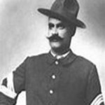
Sgt. Benjamin Brown
-
-
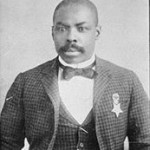
Corporal Isaiah Mays
-
-
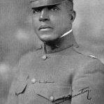
Colonel Charles Young
Tucson recently proclaimed July 28 “Buffalo Solider Resolution Day.”
The proclamation was conducted by the Honorable Jonathan Rothschild and the Honorable Richard Fimbres.
This is part of Tucson’s Buffalo Soldiers Memorial Project, which is a collaboration between City of Tucson, Ward 5, Arizona Historical Society, The Greater southern Arizona Area Chapter, 9th and 10th Cavalry Association, 9th Memorial Cavalry, Inc., 10th Memorial Cavalry, Inc., Omega Psi Phi Fraternity and Arizona Heritage Tours.
If you don’t reside in Tucson, still feel free to celebrate the Buffalo Soldiers by reading about their history below (retrieved from the Buffalo Soldier Proclamation Program):
In 1866 Congress authorized, for the first time, African Americans to serve in the peacetime army of the United States. Two cavalry and four infantry regiments were created and designated the 9th and 10th U.S. Cavalry regiments and the 38th, 39th, 40th, and 41st U.S. Infantry regiments. The four infantry regiments later became the 24th and 25th Infantry regiments. The all-African American regiments, commanded mostly by white officers, were composed of Civil War veterans, former slaves, and freemen.
Throughout the period of the Indian Wars, about 20% of the U.S. Cavalry troopers and 8% of the infantry soldiers were African American. The Buffalo Soldiers rose above the challenges of harsh living conditions, difficult duty, and racial prejudice to gain a reputation of dedication and bravery. Thirteen Medals of Honor were awarded to Buffalo Soldiers during the Indian Wars, and five were awarded during the Spanish-American War. Stationed on the U.S. frontier from the 1860s to the 1890s, Buffalo Soldiers played a major role in the settlement and development of the American West. Following the first Buffalo Soldiers, African American regiments later served in the Spanish-American War, Philippine Insurrection, Mexican Punitive Expedition, World War I, World War II, and the Korean War. In the 1950s, African American regiments were disbanded when all military services were integrated. At that time, for the first time, black and white soldiers served together in the same regiments.
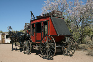
Buffalo Soldiers were known to have played a significant historical role in at least six parks in the American Southwest: Fort Davis National Historic Site (FODA) and Guadalupe Mountains National Park (GUMO) in Texas; Fort Larned N.H.S. (FOLS) in Kansas; and Fort Bowie N.H.S. (FOBO) and Chiricahua National Monument (CHIR) in Arizona. Buffalo Soldiers were also stationed at Fort Huachuca (still an active military installation) near Coronado National Memorial (CORO) in Arizona. Throughout these sites, the soldiers protected traffic on the San Antonio-El Paso Road, helped build Fort Davis into one of the largest posts in Texas, participated in campaigns against Native Americans, protected settlers and guarded stage stations, constructed roads and telegraph lines, and explored and mapped previously unmapped regions. Colonel Charles Young was the first African-American to head the National Park System.