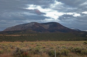
Escudilla Mountain
Escudilla Mountain is located in the White Mountains of Eastern Arizona near the town of Eagar. It is considered the third highest mountain in Arizona, and like the others, is volcanic in origin. Though there are eleven higher named summits in the state, most are considered subpeaks of either Humphrey’s Peak or Mount Baldy. The name Escudilla is Spanish for “a small bowl,” and the mountain may have been named by early Hispanic settlers in the region, or possibly by a member of Coronado’s 1540 Expedition through the Southwest. In 1984 the Escudilla Wilderness Area was created, encompassing 5,200 acres of Escudilla Mountain and the surrounding area of the Apache National Forest. Two primary trails are utilized for this moderate dayhike. The scenic Escudilla National Recreation Trail #308 is used by most hikers while the steeper Government Trail #119 receives less traffic since it is slightly longer with fewer views of the surrounding lowlands. They may be combined to form a loop. The fire lookout tower on Escudilla Mountain is the highest in Arizona although it is not on the true summit. A climb to the top of it offers spectacular views into New Mexico and the surrounding area. Mount Baldy can be seen to the west. The tower is occupied daily and permission should be acquired from the lookout before ascending the steps. Permission will not be granted if it is raining. For more information and park updates, visit: http://www.fs.usda.gov/recarea/asnf/recreation/recarea/?recid=45293&actid=50.
