Blog Archive for Author : 23

The Cove


The Sierra Vista Aquatic Center, aka “The Cove,” is a 36,500 sq ft facility that contains 11,347 sq ft of pool water surface, which equates to over 575,000 gallons of water. The Aquatic Center boasts a 0′ depth, or “beach”,’ entry and eight 25 yard lap lanes for lap and competitive swimming, and a wave machine with several wave patterns for Open Swim. Smaller children can enjoy a water play area of less than 2-feet of water where they can pretend to be pirates on the pirate ship slide.For those looking for a more relaxing time, there is also a warm water therapy pool that is always 92 to 94 degrees and complete with water jets. The diving pool includes two 1 meter diving boards and one 3 meter diving board. And just for fun, there are two enclosed tube slides that will take you on a ride inside AND outside the building! The Cove also has locker rooms for men, women, and families with small children. Lockers are available free of charge for the day, however, customers are strongly encouraged to bring a lock in order to secure their valuables. Locks are also available for purchase at the front desk. A snack bar and outdoor patio are available as well to hang out and take a break from all the fun. For more information, please visit: http://www.sierravistaaz.gov/

Sky Island Scenic Byway

sky island scenic byway_southern_7.28.14

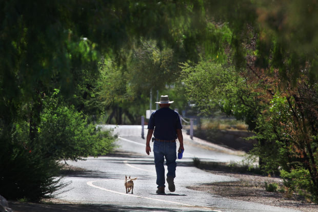
Climbing more than 6,000 feet,the Sky Island Scenic Byway begins with forests of saguaro cacti in the Sonoran Desert and ends in a cool, coniferous forest on the Santa Catalina Mountains. Prepare yourself for breathtaking views and a climate change that would be similar to driving from Southern Arizona to Northern Montana. Each thousand feet up is like driving 600 miles north offering a unique opportunity to experience 4 seasons in one trip.

The scenic drive begins at the outside edge of Tucson. If you are coming from I-10, take exit 256 and follow East Grant Road for 8 miles. Turn left onto East Tanque Verde Road and continue for three miles until East Catalina Highway on your left. The start of this scenic drive is in 4 miles as you enter the Coronado National Forest. This road is sometimes referred to as Mount Lemmon Highway or Hitchcock Highway.

If you are traveling this route in the winter, keep in mind that temperature differences from bottom to top is around 30 degrees and that upper portions may be closed due to snow. And in any season — bring water, extra clothes and gas up beforehand as there are no stations along the Catalina Highway.

As the road climbs among the Saguaro cacti and brittlebush, enjoy hairpin curves as you arrive at the Babad Do’ag Viewpoint (V1) which overlooks the desert cacti studded Tucson Valley, the Rincon Mountains, and the Tucson Basin. There are interpretive signs at the lookout and if you’re up for a longer hike — try the moderate 5-mile round trip Babad Do’ag Trail. Incredible desert vistas of saguaro, wildflowers and mountains await.

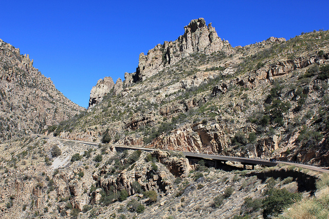
Continuing up the road, you enter the Molino Canyon. The road hugs the canyon’s cliff until the Molino Canyon Overlook (V2). The overlook offers a short hike to a creek and series of waterfalls. Towards the center of the canyon is the Molino Basin, home a campground and trailheads for a variety of hikes. Hiking here is especially fascinating due to the transition from desert to a forest dominated by cottonwood, oak, sycamore and willow trees within a very short distance.

Each turn of the road reveals a new perspective. As you enter Bear Canyon, the forest transforms once again into a lusher, cool environment with flourishing cypress, juniper, pine, sycamore, and walnut trees. Granite pinnacles soar into the sky, and with rocky outcroppings and stony hoodoos, some of Arizona’s best rock climbing is found here.

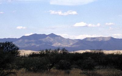
Next stop, Windy Point (V3) offers the most amazing views along the entire drive. Wind-whipped rock formations, views of the Huachuca, Patagonia, and Santa Rita Mountains, and the Tucson Basin await at 6,400 feet of elevation. On clear days, you may even see the Sierra de San Antonio in Mexico.

Geology Point Vista (V4), offers another spectacular viewpoint. Sweeping panoramas and precariously perched rocks create a surreal and photogenic landscape.

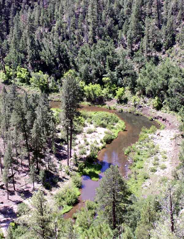
From here, you climb through forests of ponderosa pine. Rose Canyon Lake (W1) is stocked with trout and surrounded by absolute beauty; this seven-acre lake is a perfect stop for fishing, picnics, and camping in the Rose Canyon Campground. Keep an eye out for the turn off to Rose Canyon. Shortly afterwards, you arrive at the San Pedro Vista (V5) which overlooks the San Pedro River Valley, a desert between the Tortilla and Galiuro Mountains. From this stop, enjoy the 4-mile hike around Green Mountain to the General Hitchcock Campground.

Shortly after the viewpoint is the Palisade Information Center (I1). Self-guided displays inform about the Coronado National Forest and it’s a great location to get more information about hikes. Two of the most popular are the Butterfly Trail (H2) and Crystal Springs Trail (H3) with trailheads one mile from the center. Both trails are long, but you need not do the entire trail to enjoy the shaded, dense forests. Butterfly Trail (H2) features such a diverse biology, it has been designated a Research Natural Area. Wildflowers and butterflies are abundant and having a species field guide will come in handy. If you are up for a challenge, the medium-to-difficult Crystal Springs Trail will bring you to Mount Lemmon’s summit.

Experience the sky up close at the Mount Lemmon SkyCenter (A1). There are daytime and after-dark programs using their new 32-inch Schulman Telescope which is open to the public.

This scenic drive officially comes to an end as you arrive in the quaint town of Summerhaven, which features a General Store, shops and restaurants. While here, consider a few short side trips. For spectacular views in every season, Mount Lemmon Ski Valley, the southernmost ski area in the US, can be reached via East Ski Run Road. The ski hill offers an opportunity to ride the ski lift for breathtaking vistas at 9100 feet. Continue a few miles further and join onto Summit Road (T1). At the road end is the actual summit of Mount Lemmon, an amazing way to end this scenic drive.

Granite Basin

Photo courtesy of http://bit.ly/1uHpfJp

Photo courtesy of http://bit.ly/1uHpfJp

Granite Basin Recreation Area is the perfect hike for those who wish for an adventure beyond hiking. The public can camp, bike, fish, have a picnic and go horseback riding. Trails of the recreation include Balancing Rock Trail, Cayuse Loop, Clark Spring Trail, Hokaygon Trail, Metate Trailhead, Mint Wash Connector Trail, Surprise Spring Trail and West Lake Trail.


Kinder Crossing – Mogollon Rim

Photo courtesy of: http://bit.ly/1n3rVat

Photo courtesy of: http://bit.ly/1n3rVat

Hiking is, naturally, a very hot activity in Arizona. Kinder Crossing allows you to take a break from the heat with its picturesque access to East Clear Creek. Hikers of this trail can have a picnic and go swimming in the cool pools of water that align the hike.

Hikers of Kinder Crossing also get an awe-inspiring view of the Mogollon Rim. Limestone and sandstone steps offer the hikers footholds along a series of switchbacks.

Clarkdale Copper Museum

copper art museum_clarkdale_7.29.14

Image courtesy of tripadvisor.com

Just as Arizona is known as the “copper state,” it stands to reason that there should be a copper museum. While North America in itself is the largest copper producer in the world, Arizona sits on top amongst the states in being at the heart of copper production.

Most times when one encounters a museum – especially devoted to a natural resource – one would envision displays of pieces of the resource in its natural form, in small and large exhibits. However, this building of unique metal history shows through the Ages what man has done with the metal – “art of the average Joe” is what it could be deemed.  Out of the seven primary natural metals, copper was discovered in 9000 B.C. and its first use was in the form of weapons. Going from there, people constructed various items out of copper as well, to include kitchen and shop tools, and architecture.

The exhibits reveal copper art and collections for study, which were created by coppersmiths, soldier artists and braziers; many of whom were masters in their trade.  In addition, copper artifacts with an emphasis on American and European works-of-art from the 16th to the 21st century are all on display in this multi-room facility.

The Copper Art Museum is a new museum with roots that can be traced back to 1919, where an antique shop was located in Northern Minnesota.  In the early 1960’s copper wares were collected throughout Europe and later sold in the U.S.A. at on-the-road shows throughout the Midwest during the 1970’s.  The 1980’s – 90’s saw an increase in purchases and sales of copper artifacts from Europe and the U.S.A.

In the early 2000’s the collection was so large that plans of a museum came to life and a location was sought.  Later Clarkdale, Arizona was chosen as the site for a museum of copper art showcasing Arizona’s most precious treasure.

Montezuma Castle

montezuma castle_2_verde valley_8.4.14

On December 8, 1906, President Theodore Roosevelt celebrated the passage of the Antiquities Act by declaring four sites of historic and cultural significance as our nation’s first National Monuments. Among these was Montezuma Castle, which the President identified as a place “of the greatest ethnological value and scientific interest.” Although very few original artifacts remained in the structure due to intensive looting of the site, Roosevelt’s decision assured the continued protection of one of the best preserved prehistoric cliff dwellings in North America. Montezuma Castle National Monument quickly became a destination for America’s first car-bound tourists. In 1933, “Castle A”, a 45-50 room, pueblo ruin was excavated, uncovering a wealth of artifacts and greatly enhanced our understanding of the Sinagua people who inhabited this riparian “oasis” along Beaver Creek for over 400 years. Early visitors to the monument were allowed access to the structure by climbing a series of ladders up the side of the limestone cliffs. However, due to extensive damage to this valuable cultural landmark, public access of the ruins was discontinued in 1951. Take a stroll through time, while enjoying the canopy of trees that shade the walkways, as you gaze at the amazing cliff dwellings, or walk over to the adjoining creek to learn how the Sinuagua people relied heavily on this precious water source for survival. Now, approximately 350,000 people a year gaze through the windows of the past during a visit to Montezuma Castle. Even 600 years after their departure, the legacy of the Sinagua people continues to inspire the imaginations of all.

World’s Largest Kokopelli

World Largest Kokopelli

Located off of I-17, in Camp Verde, the World’s Largest Kokopelli sits in front of a souvenir shop luring travelers and tourists in to the parking lot of the Trading Post.

The giant statue is made from hand shaped and welded steel. Lowell Johnson, then owner of what at the time was the Montezuma Trading Post, came up with the idea to build the kokpelli. Prior to the kokopelli sat a hot pink 1920’s automobile in effort to attract tourists. Johnson, a local business man, and owner of the Oak Creek Terrace Resort, brought in an experienced blacksmith/artist and sketched out the design right on the sales counter. Made of 1/4 inch plate steel, the hand shaping and welding of the structure took weeks as the 12 cubic yard cement foundation cured. The statue’s instrument houses a speaker that plays music to visitors at they shop. By the end of the project, it had cost more than $25,000. For a while, there was a price tag hung in the event an interested buyer came along.

Copper Creek/ Sibley Mansion

sibley mansion_2_8.4.14

Photo courtesy of americansouthwest.net

The Sibley Mansion was home to Roy and Belle Sibley. Roy was a mining company managers and his wife was the town’s first postmaster. In 1908, the Sibleys started their work on the mansion. There were 20 rooms within the mansion, it was built of stone and had polished oak floors, picture windows and full-length mirrors. The mansion was the center for social activities in the area. It is rumored that the Sibleys entertained some of the social elite including the governor of Arizona. While the Sibleys moved out of the home in 1910, Martin Tew turned the property into a ranch and called it Monte Bonito in 1917. Tew was a nature lover and wrote poetry, which he shared with others by leaving it on trees for people to read. In 1933, the Arizona Molybdenum Corporation was mining in the area. When the San Diego Union reported Copper creek as a town that was crime-ridden and wild, residents cleared the town out and businesses, including those at Copper Creek, closed. Copper Creek/ Sibley Mansion is brought back to life as residents venture to see the spectacular piece of historic Arizona. The trail begins at the intersection of River Road and Copper Creek Road. Visitors are to tread cautiously, though, as there is active mining and cattle ranching in the area.

Julian Wash Archaeological Park

julian wash archaelogical park_southern_7.28.14

This Archaeological park features a multi-use trail and interpretive signage about the Julian Wash archaeological site and St. Luke’s Orphanage, which also used to be at this location.

Visitors of this park will get to learn about Tucson’s 4,000-year history of continuous settlement and agriculture.

There are also bike routes within this park. Travelers have found a 40.42 mile bike ride within the area. This particular bike ride has a total ascent of 534.79 feet and has a maximum elevation of 2,814.76 feet.

Another route within the park showcases the natural beauty of the Sonoran Desert as it travels form Santa Cruz River Park to S. Rita Road in southeastern Tucson. The trail offers views of distant mountains and connects several other parks together.

Las Cienegas

Photo courtesy of darkerview.com

Photo courtesy of darkerview.com

More than 45,000 acres of rolling grasslands and woodlands in Arizona’ Pima and Santa Cruz counties are protected as a National Conservation Area. Here lies Las Cienegas.

The National Conservation (NCA) area is located in the transitional zone between  the Sonoran Desert and Chihuahuan Desert.

The region’s rolling grasslands, oak-studded hills that connect several mountain ranges and lush riparian corridors provide a great home for wildlife and a beautiful place to visit for Arizona travelers.

The Cienega Creek forms the lifeblood of the NCA and supports a diverse plant and animal community.

Feel free to camp just outside of the NCA, as there is no developed camping or picnicking facilities within the NCA. Camping at least one-quarter mile away from wildlife and livestock watering areas is allowed for up to 14 days. The two designated primitive camp and picnic areas are Cieneguita Camp Area and Road Canyon Camp Area.

If you decide to postpone this trip, Las Cienegas provides a spectacular view of the night sky during the winter.